Project Summary
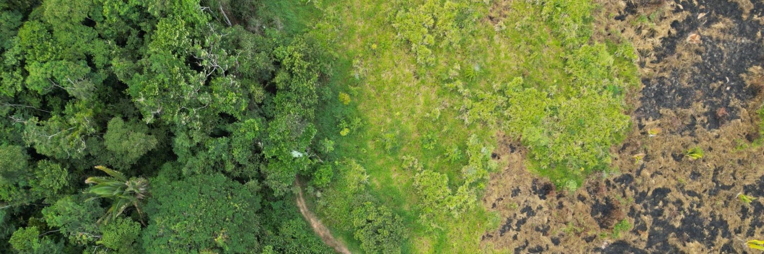
Wildfires are becoming the new normal across Amazonia. Deforestation is transforming the region at a rate of around 10,000 square km/year (half the area of Wales), and now the area degraded annually -forest logged and burned but not cut down-is greater than the area deforested. Fire has historically been rare in Amazonia, meaning that the forests are not adapted to fire and the trees often die from fires – releasing carbon (C) back to the atmosphere and amplifying global climate change. Burning of tropical forests is already releasing more climate-warming carbon dioxide than fossil fuel burning in the whole of Europe. Trees in Amazonia contain around 7x more C than humans are releasing every year, and soils contain the same amount again, so it is vital to understand what is happening to this C and minimize emissions.
As vegetation sheds its leaves, branches, and roots, or dies, some of the C released remains in the soil, and some is later decomposed and released back to the atmosphere. Carbon exists in the soil in many different forms, from new inputs from decomposing plant material to ancient C formed over millennia. Burning adds pyrogenic carbon (PyC) to the soil, a partially burnt form of C that is resistant to decomposition and could make the soil more fertile. Because soil C takes a long time to form, its conservation is particularly important.
Despite the widespread increase in fire in Amazonia, there have been few measurements of soil C fractions and dynamics in burned areas – most have focussed on natural forests. Burned forests will have different composition, forest structure, and C dynamics. Understanding how different soil C fractions are formed and lost is crucial to understand how fire and climate change affect C storage.
We propose to make major advances in understanding fire impacts, including the processes that affect the type and quantifies of soil C formed, and how C gains/losses vary over time, with soil type, and climate. We will combine new measurements with innovative modelling to inform land management strategies and C budgets.
We have already collected data from across Amazonia in intact forests that have not recently burned. Crucially our project will collect a new, comprehensive dataset from human-modified forests, including logged, burned and abandoned land. We will use an approach known as a chronosequence, where we take samples at sites that were burnt at different times in the past, so we can see how the soil C has changed after e.g. 1 year, 2 years, or up to 20 years after a fire. This will then be used to develop a state-of-the-art land surface model, JULES, which forms part of the UK Earth System Model.
At our sample sites, we will evaluate how different burn severities affect soil C, both in surface and deep soils, and how these change over time post-burning and with soil, climate, and land-use such as logging. At 3 focal sites, we will take detailed measurements of the decomposition rate of the C over 4 years, comparing measurements with different land-use, burn severity and wet vs dry seasons. Knowing what forms C takes after a fire and how fast it decomposes under different conditions will enable us to build these processes into the JULES model. We will model PyC regionally for the first time and make projections of land C changes in Amazonia over the next ~40-60 years under different management practices.
As well as transforming scientific understanding of post-fire soil C and its resilience to climate and management, our project will inform socio-environmental planning for sustainable resource use to conserve soil C. We will work with regional partners, fire managers, state and national policymakers to integrate our findings into decision-making to minimise negative fire impacts. Due to the Amazon Basin-scale of our work, these strategies are a crucial step to limit the risk of large-scale loss of soil C.
Our Research Objectives
Our project is structured around five core objectives (O) designed to build a complete picture of soil carbon dynamics, from baseline measurements to future projections.
- O1: Establish the Baseline (Intact Forests), the starting point before modern fires.
- O2: Quantify Drivers of Change (Human-Modified Forests), determining how SOC stocks and fractions change after a fire and over time.
- O3: Track Temporal Variation in Carbon Loss to measure carbon “breathing” from the soil (respiration) and see how it responds to fire and climate.
- O4: Model Future Scenarios with JULES, to predict the long-term fate of Amazonian soil carbon.
- O5: Create Landscape Predictions & Inform Policy to translate our scientific findings into actionable tools.
Header image: Ted Feldpausch